
Antarctic Ice Core records resolve competing Pole Shift Theories
A declassified CIA document called The Adam and Eve Story has generated much controversy over predictions of an upcoming pole shift (aka crustal displacement) and catastrophic events that may sweep the planet in the not distant future. The 57-page document is based on a book authored by Chan Thomas in 1963. In it, Thomas proposed a pole shift scenario that differed in significant ways with what Charles Hapgood had earlier proposed in his pioneering 1958 book, The Earth’s Shifting Crust.
Hapgood’s theory, which was endorsed at the time by Albert Einstein, proposed that the geophysical poles periodically move by as much as up to 40 degrees through crustal displacements. This phenomenon was brought about by the increasing weight of the polar ice caps which accumulate more and more ice over the millennia until they eventually generate sufficient centrifugal force due to the planet’s rotation, to make the crust move over the mantle as Einstein explained in the book’s foreword.
In The Adam and Eve Story, Chan proposed that the pole shift was much greater, as much as 90 degrees with the poles shifting into the equatorial zone in less than a day. Chan has proposed the poles would flip back and forth in this way so that Antarctica would eventually return to the South Pole region, and the Arctic would do likewise.
Each time the geographical poles did one of these 90 degree flips, there would be catastrophic winds and tidal waves all over the planet, especially in the equatorial region where the Earth’s spin was 1000 mph. Water and wind would continue to move in the westerly direction through the law of inertia, sweeping over the landmasses that traveled over the equatorial region during the shift as Thomas explained:
In ¼ to ½ a day the poles move almost to the equator, and all hell lets loose. The atmosphere and oceans don’t shift with the shell – they just keep on rotating West to East – and at the equator that speed is 1000 miles per hour. It has to be, normally, to make one rotation per day. So, while the shell shifts with the poles going toward the equator, the winds and oceans go eastward, blowing across the face of the earth with supersonic speeds, inundating continents with water miles deep….
You can see, then, that ice ages are not a matter of advancing and retreating ice; it’s simply that different areas of the Earth are in polar regions at different times, for different durations of time, with the changes between positions taking place in a fraction of a day. [The Adam and Eve Story, pp.13-14]
The following video illustrates what happens during one of these 90 degree shifts, and what Thomas was proposing for what’s to come. One can easily see how devastating such a 90 degree shift could be and why the CIA may have been motivated to suppress such information.
According to Ben Davidson, author of the popular Earth Catastrophe series, this flipping back and forth would address paleomagnetic studies that show that the magnetic poles have been in their present locations for millions of years. Davidson concluded that this made Thomas’ pole shift theory much more compelling than Hapgood’s. In fact, Davidson believed Hapgood was putting out his theory as a “limited hangout” by the CIA in order to put the truth out in a way that later could be easily discredited.
Unfortunately for Davidson, ice core samples from Antarctica clearly support Hapgood and not Thomas’ theory. Ice core samples from East Antarctica date back as much as 1.5 million years. The following diagram illustrates ice core samples taken from different Antarctic regions and show how far back in time the ice sheets date.
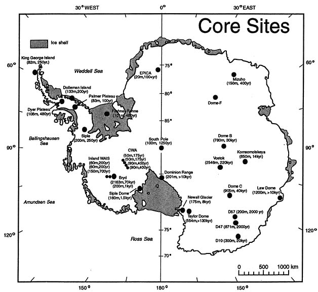
The results from the ice core drill sites show that East Antarctica has been covered by ice for hundreds of thousands years, with Lake Vostok having some of the oldest discovered ice (220,000 years). Older ice core samples than those recorded in the above map have subsequently been found both at Lake Vostok (400,000 years), and the Dome C area (800,000 years) as shown in NOAA records.
A subsequent 2013 study asserted that ice core samples of up to 1.5 million years are most likely to be found in the Dome C area of East Antarctica. Put simply, scientists agree that East Antarctica has been covered by ice sheets for at least 1.5 million years, and likely much longer than that.
In contrast, the ice core samples in West Antarctica are only a few centuries old, with only one so far matching the age of many of the East Antarctic sites. This site is in the drilling area designated Boyd whose ice was found to be 70,000 years old as the above map illustrates.
The ice core records show conclusively that much of the Antarctic continent has been located in the polar zone (latitudes greater than 66 degrees) for at least 1.5 million years, and not in the equatorial zone (O-23 degrees latitude) as proposed by Thomas. Hapgood’s theory offers a better explanation for why only part of Antarctica has been ice-free for significant periods. But how do we explain the 70,000 year old ice sample found in the Byrd region of West Antarctica?
To find a definitive answer to where the geographical poles have been located and then move via crustal displacements to new positions, preserving some but not all the ice accumulated before the displacement, we can turn to the work of Rand and Rose Flem-Ath, authors of When the Sky Fell.
In their well-documented book, they used a range of archeological and fossil records to show where ice sheets have been found over the last 100,000 years, and how these positions had changed due to crustal displacements as first proposed by Hapgood. To date, I have found no other authors laying out such a compelling case for using available scientific data to track the respective positions of the geographic poles during the last 100,000 years.
Their findings provide a clear explanation for the varying ages found in the ice core samples extracted from different regions of Antarctica; and why Hapgood, rather than Thomas, provides a more accurate explanation for how the crustal displacement theory works.
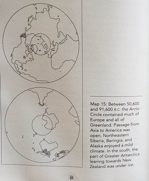
First, I begin with Flem-Aths’ illustration of the positions of the North and South poles prior to 91,600 BC. It shows how the bulk of East Antarctica was inside the Antarctic circle, while West Antarctic lay in the temperate zone – similar to the present day location of New Zealand. Note the South Pole was located just off the coast of East Antarctica at the time, while the North Pole was located in Alaska.
Importantly, the Dome C area containing some of the oldest ice core samples found to date was located within the Antarctic circle, thereby preserving much of the ancient ice sheets acquired over the previous 1.5 million years or more.

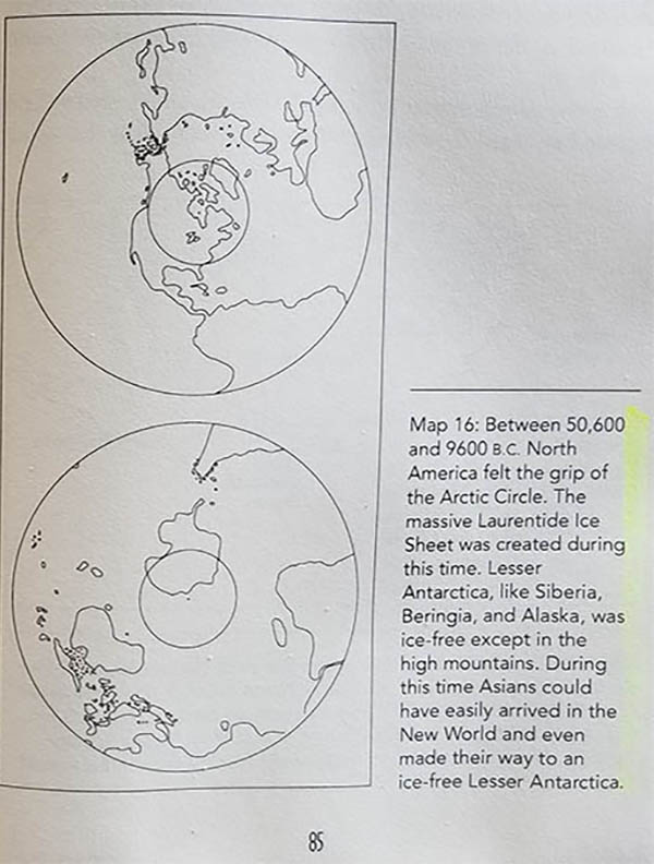
The next diagram shows the Antarctic continent in relation to the South Pole after a crustal displacement led to a pole shift around 91,600 BC. Consequently, during the period from 91,600 BC to 50,600 BC, much of lower region of West Antarctica, along with the Transantarctic mountains, lay within the Antarctic circle, while the Palmer peninsula and significant areas of East Antarctica lay within the temperate zone.
Once again the physical South Pole was located over the ocean, rather than the Antarctic continent – this time off the coast of West Antarctica – adjacent to the Ross Sea. The geophysical pole had moved approximately 40 degrees from off the coast of East Antarctica to just off the West Antarctic coast during the 91,600 BC pole shift.
This is very close to what Hapgood had proposed was the crustal displacement that would occur during a pole shift. Significantly, it is far less than the 90 degree pole shift claimed by Thomas.
Importantly the Dome C area remained entirely within the Antarctic circle thereby preserving its ancient ice sheet. Furthermore, the Byrd area where the 70,000 year old ice sample was found, had been moved from its prior location in the temperate zone prior to the 91,600 BC pole shift, to deep inside the Antarctic circle. This allowed the accumulation of ice to begin, thereby accounting for its estimated age.
The next pole shift occurred around 50,600 BC, and an illustration provided by the Flem-Aths shows the approximate locations of the poles from 50,600 BC to 9,600 BC.
Around 50,600 BC, the South Pole has flipped back to the other side of the Antarctic continent, where it again lay just off the coast of East Antarctica. An approximate 30 degree pole shift had occurred, which is again consistent with Hapgood’s estimate for the cyclic crustal displacements that the Earth undergoes. It’s important to emphasize that the 50,600 BC pole shift was far less than the 90 degree shift predicted in Thomas’ theory.
Most of East Antarctica was again located inside the Antarctic circle, both preserving its ancient ice sheets and allowing them to expand. The Byrd region, containing the 70,000 year old ice core sample, was now located just outside the Antarctic Circle. Its marginal position marginally inside the temperate zone, which would allow the Byrd region to preserve the bulk of its ice sheets similar to the glaciers of southern New Zealand.
The period from 50,600 BC to 9600 BC is significant since it corresponds to the last time major portions of the Antarctic continent lay outside the polar circle. The bulk of West Antarctic lay in the temperate zone, and its coastal area would therefore have been ice free. Significantly, West Antarctica’s coastline and interior would have been navigable, just as the 1513 Piri Reis Map showed.
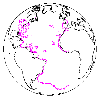
In the following diagram, the Piri Reis map is superimposed over a map of the globe showing how the Antarctic coastline from the tip of the Palmer Peninsula, all the way down its eastern flank to East Antarctica was known to ancient sea captains.
Also vital to understand is that this period, 50,600 BC to 9600 BC corresponds to the Atlantean civilization that Plato wrote about in his famous dialogues, Critias and Timaeus. Plato explained Atlantis’ extensive island system and waterways deep into its interior, and how it was the hub for a mighty empire that ruled over much of Africa, Europe, and Asia.
This finally takes us to the 9600 BC pole shift that led to the entire Antarctic continent, being moved to wholly inside the Antarctic circle. The magnitude of the Earth crustal displacement moving the South Pole from its previous location just off the East Antarctic coast to its present location was approximately 20 degrees. Again, significantly less than what Thomas was proposing in his crustal displacement theory.
The Flem-Aths contend that Atlantis was located in Antarctica and that the remnants of this legendary lost civilization today lie under the West Antarctic ice sheets. This is consistent with what several whistleblowers and insiders have been revealing concerning the discovery of a flash-frozen civilization under the ice sheets.
If the Flem-Aths and others are right that Plato’s Atlantis is buried under the Antarctic ice, this gives us a means of estimating the devastation that would be caused by a crustal displacement of approximately 20 degrees. It would be sufficient to wipe out the coastal regions all over the globe such as the low-lying archipelagos such as Atlantis, but allow those living in elevated or mountainous regions to survive the subsequent tsunamis, earthquakes, and hurricanes accompanying a pole shift.
When ice core samples are examined in relation to what we know about Earth crustal displacement theories proposed by Hapgood and Thomas, they lead to a clear conclusion. The examination of ice core samples from different parts of Antarctica support Hapgood’s theory that earth crustal displacements happen periodically, and involve Pole Shifts of up to 40 degrees.
The Flem Aths book, When the Sky Fell, gives us a means of tracking the most significant pole shifts over the last 100,000 thousand years, and illustrates how these have occurred in a manner that is consistent with what ice core samples tell us.
Thomas’ theory that the Earth regularly experiences 90 degree pole shifts that flip the poles back and forth from equatorial regions is not supported by Antarctic ice core records. While it is comforting to know that the Earth is unlikely to experience anything like the cataclysmic 90 degree pole shift predicted by Thomas, it is sobering to know that even a 20 degree pole shift devastated the worldwide Atlantean civilization 11,600 years ago.
The likelihood that we will soon experience a pole shift due to another crustal displacement caused by solar activity, cosmic rays, collapse of the Earth’s magnetic field, activity from the Earth’s core, and/or a rapid melt off of the West Antarctic, appears to be quite high as I have suggested in previous articles examining Davidson’s Earth Catastrophe series.
This calls for an unprecedented level of transparency by governments in sharing data about Antarctica’s history, what is known about prior pole shifts, and the disclosure of suppressed technologies that would enable the bulk to humanity to prepare and escape from impending cataclysmic events.
© Michael E. Salla, Ph.D. Copyright Notice
Further Reading
- Cosmic Rays as Triggers for Solar Flashes, Earth Core Eruptions & Pole Shifts
- Massive Pole Shifts are Cyclic according to Declassified CIA Document
- Impending Solar Flash Event Supported by Scientific Studies & Insider Testimony
- The Coming Solar Flash & the Galactic Federation – Q&A with Corey Goode
- More Scientists Confirm Volcanoes Rapidly Melting Antarctica’s Ice Sheets
- Global Elite Prepare for Massive Solar Eruptions claims Secret Space Program Whistleblower
Antarctica, Atlantis, Ben Davidson, Chan Thomas, Charles Hapgood, Pole Shift